Abracadabra!


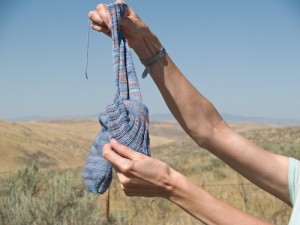
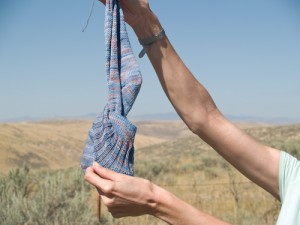
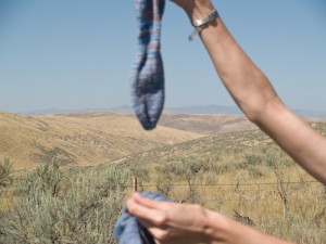
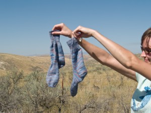
Ta-da! A sock comes out of another sock! And except for weaving in the cast-on tail, they’re ready to go right on your feet! (Okay, I did have to weave in the inner sock’s toe tail after the fact. And I could have done the cast-on tails before I separated them, but I didn’t.) Sure enough, the ankles are really baggy, but I wisely decreased the gussets down to a foot circumference I knew would work, and the deep ribbed cuffs are quite comfy and the socks don’t sag when you’re wearing them. Plus if I ever suffer swollen ankles from, say, pregnancy or unguarded cavorting over the Devonshire countryside á la Marianne in Sense and Sensibility, I’ll have just the socks for the occasion. (I must tell you these circumstances look equally unlikely at the moment, but it never hurts a girl to be prepared.)
Will I knit two socks together in this manner again? Probably not, as it’s simpler to knit them side by side on two circulars. One has more freedom to work interesting stitch motifs (or ANY stitch motifs) that way, and not having so many stitches crammed onto my favored 5″ dpns is easier on the hands. I found ladders at the needle joins were unavoidable. But for a utilitarian pair of vanilla socks, these will serve quite well. The Koigu was happy on the US #1.5 needles, and I’m glad to have finally knit up these two pretty skeins, given to me by Formerly Abundant Lisa in New York many years ago. (Lisa still possesses an abundance of many fine qualities… she just doesn’t blog anymore, and I miss her. Also, it is her birthday today. Happy birthday, Lisa!) I’ll wear these often.
Hey, anybody out there familiar with the landscape of eastern Oregon or in possession of a fine atlas? These pictures were taken just off I-84 where it follows the Oregon Trail northwest of Ontario in Malheur County. We were about to drive into some beautiful, chalky, rumpled hills. They reminded me of oddly of Yorkshire, were it hot and dessicated and its heather replaced with sagebrush. These pictures don’t show the segment of golden, folded, heat-hazed landscape I liked best, as there weren’t any turnouts and I didn’t fancy the Camry’s modest acceleration abilities against the flotilla of heavily laden trucks that accompanied most of our drive to Idaho. I cannot find out whether these hills have a name. Tub Mountain is marked as their high point, but none of my maps, paper or Google, is specific enough to tell me more.
Come to think of it, I don’t believe we’ve rewarded good research on this blog since I wanted to know how the Shetland wool called mooskit came by its name. It’s time we did so again. And I feel knowledge of geography is frankly undervalued now that your cell phone can direct you absolutely anywhere and rob you of the adventure of exploring. Be the first to find me the name of these hills and I’ll send you a little something from ye olde yarn stash (which I am reorganizing at last). Or some chocolate, if you don’t knit. (I hope there’s some romance in the name. I’ll be disappointed if it’s dull… but the reward will stand.)
2 September: I think I’ve set you an impossible task. I’ve looked at a zillion different maps and I just can’t find that those hills have a name. I’m going to declare Molly the winner of the contest since she found Pine Tree Ridge, one of the only two named topographical features in the area. (The other is Moore’s Hollow, which I think is sort of visible as a cleft in the distant background of these photos.) Pine Tree Ridge is just at the edge of the region I’m speaking of. I can’t say I saw a single tree of any kind there, but perhaps there was once a pine tree and that’s why that particular ridge was notable. Anyway, we’ll try to have an easier contest again before year’s end!


Posted: August 30th, 2009 at 5:02 pm
Congrats on the socks! They are quite magical.
Posted: August 30th, 2009 at 5:26 pm
You are the COOLEST. I am hoping to learn that technique this winter!
Posted: August 30th, 2009 at 5:58 pm
Things to love about this post:
1. The sock trick.
2. That you performed the sock trick apparently by stopping at the side of the road just where the Inland Empire starts to get pretty again just because.
3. Your expression on having performed the trick.
4. That you did it and I truly feel released from ever having to do this myself.
Posted: August 30th, 2009 at 6:03 pm
Love the socks!! I’ve always wanted to give the two socks at a time a try, you may have given me the push to do it. =)
Tub Mountain is part of the Blue Mountains – they are in the NE part of the state. You may also have seen parts of the High Lava Plain and/or Owyhee Uplands as you traveled. I’ve studied the geology in school, but have yet to travel that area of I-84 to surely know the lay of the land.. =}
http://www.oregongeology.org/sub/learnmore/GeologisSightseeing.HTM can give you a little overview of things. If you’d like more info, jlmk!
Posted: August 30th, 2009 at 6:56 pm
I have no idea if those hills have a name, but I’ve ridden or driven that road many a time. I grew up in Boise, but I started out in a smaller town, and when I was little, I sometimes got to ride in Dad’s truck as he made grain deliveries from his granary to (??) I have no idea where, but it was in the big city of Ontario.
My father, you will be pleased to know, drove like a sensible human being whether he was in that truck, the family car, or the Porsche 356SC he bought after I graduated from high school and sold to one of my boyfriends, who promptly wrecked it.
Posted: August 30th, 2009 at 7:14 pm
No idea about the hills, but that is some very interesting sock magic!
Posted: August 30th, 2009 at 9:20 pm
Was it Pine Tree Ridge?
Cool sock trick, by the way!
Posted: August 31st, 2009 at 12:34 pm
From our Nat. Geographic map (that boxed set), the Blue Mtns range pretty much north/south, and west of 84 as you drove nw from Ontario, OR. 84 crosses the Blues around La Grande. To the east of and parallel to 84 is the OR Trail and then the Powder R., with the Wallowa Mts. beyond and to the north. Hell’s Canyon and the Snake run n-s through the Wallowas. Also, about 50 miles n-n-w of Ontario are Lookout Mtn (7120′) to the right of 84 and Bald Mtn (6667′) to the left. Too bad you didn’t have time to stop in Baker City – there’s an OR Trail interpretive center there. Next time.
The Hell’s Canyon area is supposed to be beautiful in Sept. Hope to get there sometime.
I’ll bring the map when we see you!
Love,
Mom
Posted: September 1st, 2009 at 6:01 am
In Eastern Oregon you will find the finest pizza in the world! Paisano’s in Baker City quite wortht he drive.
Jana in Kansas
Posted: September 1st, 2009 at 6:07 am
Those pictures are almost as good as being there to see it in person. Brava!!
Posted: September 1st, 2009 at 12:54 pm
I’ve always wanted to see this done – thought not enough to push through the pain barrier and attempt it myself – thank you for the painless gratification!
Posted: September 2nd, 2009 at 7:44 am
My recollections of Oregon are sketchy at best, and I never lived in that part of the state. Your photos are gorgeous and I loved taking a few minutes to look at maps and refamiliarize myself with the state.
Posted: September 3rd, 2009 at 11:23 am
That sock trick is totally cool. Not sure I’ll ever take the time to do that, myself, but just knowing that you can knit a sock inside another sock makes me feel better about the world, somehow.
Posted: September 5th, 2009 at 7:47 pm
Fabulous sock trick!
And I could smell the sagebrush by just looking at the photo. Mmmm—-a whiff of the old home state. I’ve been down that very road.